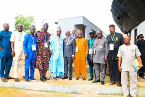
Surveyor General affirms embracing new technology to improve surveying and mapping

The Surveyor General of the Federation, SGOF, Surv. Abduganiyu Adeyemi Adebomehin has vowed that the agency will deliver its statutory mandate by embracing new technology to improve surveying and mapping.
Surv. Adebomehin, who made the remarks at the ongoing 59TH Annual General Meeting & Conference of the Nigerian Institution of Surveyors, NIS, ongoing in Enugu, said the desires was made possible with great support of President Bola Ahmed Tinubu.
The theme of the AGM is “Harnessing geospatial intelligence in the new world: Innovation and Opportunities for Sustainable Development.”
Surv.Adebomehin, who was represented by a Director in the Office of the Surveyor General of the Federation, Surv Semiu Ayinde, noted that, “The office of the Surveyor General of the Federation being the apex mapping agency of the Federal Government Nigeria, has continued to strive to leave up to her statutory mandate by embracing new technology for improved surveying and mapping.”
He said, “his has been made possible with great support of the President and Commander In Chief: His Excellency Bola Ahmed Tinubu GCFR.”
Dignitaries, who graced the occasion include the Surveyor General of the Federation (SGOF) Surv. Abudulganiyu Adeyemi Adebomehin, Former Minister of Power and the current Vice Chancellor, University of the Niger Prof Chinedu Nebo and the Governor of Enugu State Peter Ndubuisi Mbah among others.
In his lecture, Prof Nebo said “Geospatial Intelligence has emerged as a transformative force in global development, integrating geographic data with cutting edge technology such as artificial intelligence, AI, machine learning, remote sensing and big data analytics.”
He explained that “Geo spatial intelligence is a veritable tool that Nigeria needs to power its journey through sustainable development that will guarantee unprecedented socioeconomic growth and it is crucial that our policymakers learn the importance of experts in this field as well as those in the general disciplines of town and regional planning in the governance of regional development commissions throughout the country.”
While declaring the AGM open, the Governor of Enugu State, Peter Mbah said “This gathering is far more than a routine professional convention. It is a critical convergence of minds committed to shaping the future of our environment, development and our national planning system.
“Your work at surveillance sits in the foundation of every meaning infrastructure project, every parcel of land properly documented, and every boundary that defines peace and conflict.
“You are the unseen architects behind every maps future from the onset of this administration we prioritised the strengthening of survey institutions.
“One of the landmark intervention is the procurement of real time kinematic drone instrument which has transformed our surveying process in Enugu.”
Mbah claimed that, “Their mapping system led to the transformation in education, setting up 60 smart green schools in every single ward in the state, farm Estate, security infrastructure, private sector investment, and flagship developments projects.’’
In his opening address, the NIS President Surv. Dr Matthew Olomolatan Ibitoye said ‘’The Surveying and Geo informatics profession continues to play a pivotal role in the acquisition, processing and management of geospatial data in response to complex environmental and developmental challenges
“It is time for Nigeria to establish a coordinated National Geospatial Data Infrastructure in line with global best practices . Such a framework will significantly support the actualisation of President Bola Ahmed Tinubu GCFR’s Seven point agenda –especially in infrastructural development and position geospatial intelligence as key enabler of national progress- end.”
Commissioner of Land in Enugu State , Chimaobi Patrick Okorie, while welcoming the delegates from NIS to Enugu said ‘’Enugu State truly appreciate the support and the comradeship of surveyors in the land ecosystem You have shown tremendous support and you have actually become advocates of various developmental initiatives of the Governor.
“I would highlight the signing into law of the Enugu Geographic Information Systems Law by His Excellency and point out the huge support that this institution gave us both at the point of review of the bill and the passage of that bill into law and the operationalisation of the engines like we have come to know in the Enugu Geographic Information System.
“Just last month the state has joined in the launch of the CORS –Continous Operating Reference System , in Enugu , We will therefore be excited and enjoin you to participate in various interactive sessions and technical sessions.’’
The Zonal Director of OSGOF in Enugu , Surv Mohammed Maikano took time to conduct some of the delegates from Surveyor General Office of the Federation round the newly renovated office OSGOF and also showcased the projects vehicle attached to his office.
According to him, “Our Oga has been so focused on the development of staff and offices that is why I took my time to show you people round as part of his commitment to development of Surveying in Nigeria regardless of state or station.”
